
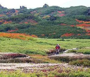
Though Japan is often celebrated for its ancient traditions and futuristic cities, it is also a land of mountains. Over seventy percent of this volcanic archipelago is covered by towering peaks and snow-capped summits. These mountains, long revered for their religious and cultural importance, offer a paradise for outdoor enthusiasts.
related places
58Mount TakaoLess than an hour from central Tokyo, Mount Takao is one of the closest nature escapes to the city. Several trails lead up the mountain and beyond. The main path is paved and passes through temple grounds before reaching the summit, which offers views of Mount Fuji on clear days. It can get crowded, especially on weekends and during the autumn foliage season in November.Around TokyoMount MitakeMount Mitake is another popular hiking spot near Tokyo, located in the mountains of Chichibu-Tama-Kai National Park. It takes just two hours to reach from the city. Hikers can explore trails through nearly untouched nature, stopping at waterfalls, small shrines, and peaks along the way.Around TokyoMount FujiMount Fuji, Japan's tallest and most iconic mountain, is climbed by hundreds of thousands each year. The main hiking season is July and August, though some facilities remain open in September. Outside these months, climbing is dangerous. Shorter, casual hikes are also available, such as walks to Kofuji and Hoeizan.Around TokyoNikkoIn addition to being a World Heritage Site, much of Nikko is a national park offering a wide range of outdoor attractions, including lakes, mountains, and waterfalls in the Okunikko area. Hiking trails connect many sights, such as the scenic walk from Ryuzu Waterfall to Yumoto Onsen via the Senjogahara Marsh.Around TokyoKamakuraKamakura is a popular cultural destination near Tokyo. A network of hiking trails is hidden in the forested hills above the city's famous temples and shrines, offering an attractive alternative way to walk between sights. The trails can be slippery after rain.Around TokyoHakoneAbout 100 kilometers from Tokyo, Hakone is a popular hot spring resort in the Fuji-Hakone-Izu National Park. There are various hiking trails around Hakone, most leading through forest with limited views of the surrounding scenery. Among them are sections of the Old Tokaido road.Around TokyoFushimi Inari ShrineFushimi Inari Shrine is an important Shinto shrine in southern Kyoto. It features thousands of vermillion torii gates forming tunnels along a network of trails that lead from the main buildings to the top of the sacred mountain behind.Around KyotoDaigoji TempleDaigoji is a major temple in southeastern Kyoto. The main complex lies at the base of a mountain, while the original temple grounds near the summit are reachable via a steep forest trail. Those who make the climb are rewarded with wooden halls set along the quiet mountainside and panoramic views.Around KyotoKuramaKurama is a rural town in the mountains of northern Kyoto, less than an hour from the city center. It is best known for Kurama-dera Temple, perched atop a steep, wooded hillside. After a 30-45 minute walk to the temple, visitors can continue on a trail over the mountain to Kibune in the neighboring valley.Around KyotoMinoo ParkMinoo Park is a forested valley just north of Osaka's urban sprawl, only 30 minutes from the city center. It is the closest nature spot to the city. In autumn, it is one of the best places in the Kansai Region to see fall colors in a natural setting, as opposed to temple and garden foliage.Around OsakaYamanobe-no-michi TrailThe Yamanobe-no-michi Trail is an ancient road in Nara Prefecture, the oldest road mentioned in Japanese records. Today, it is a pleasant hiking trail through rural landscapes, connecting multiple shrines, temples, and other points of interest.Around OsakaMount YoshinoYoshino is a temple town on the mountain slopes of Nara Prefecture. Japan's most famous cherry blossom spot, Yoshino's mountainside is covered by over 30,000 cherry trees that usually bloom from early to mid April. Visitors can enjoy the trees along a small network of hiking trails. A more difficult pilgrimage trail to Mount Omine begins at Kinpusenji Temple.Around OsakaKoyasanKoyasan has long been a popular pilgrimage site, with a network of trails connecting the secluded mountain temple community to the outside world. The main Koyasan Choishi Michi trail is a 23.5 kilometer, 7-hour hike, but visitors can shorten the trek by accessing the trail from different points along the Nankai Koya Line.Around OsakaRishiri and RebunPart of Japan's northernmost national park, Rishiri and Rebun are two beautiful islands off the coast of northern Hokkaido. Rebun is famous for its rich flora and views of nearby Rishiri, enjoyed from various hiking trails around the island. Experienced hikers may prefer to climb the dormant volcano at the center of Rishiri.HokkaidoShiretokoShiretoko in eastern Hokkaido is one of Japan's most beautiful and unspoiled national parks. The remote peninsula's furthest reaches can only be seen from sightseeing boats or multi-day treks. Shiretoko is known for its dense brown bear population. There are also easier hikes, such as trails around the Five Lakes or to Furepe Waterfall.HokkaidoAkan National ParkAkan is a popular national park in eastern Hokkaido with three scenic lakes. It is known for natural scenery like Lake Mashu, often considered Japan's most beautiful lake. The park's hiking highlight is Mount Meakan, an active volcano offering some of the best volcanic scenery in Japan. Other hikes include Mount Oakan and a trail around part of Lake Mashu.HokkaidoDaisetsuzanDaisetsuzan, Hokkaido's largest national park, is a mountain paradise of unspoiled wilderness and the first place in Japan to see autumn colors and snow each year. The park is one of the few places where you can do week-long treks completely surrounded by nature, though there are also many shorter day hikes.HokkaidoMount TarumaeLake Shikotsuko is a sparsely developed crater lake in eastern Hokkaido, encircled by mountains including Mount Tarumae, one of Japan's most active volcanoes. Visitors can climb the barren, smoking mountain to the crater rim for views over the volcanic landscape. It is also possible to circle the crater.HokkaidoMount UsuPart of Shikotsu Toya National Park, Lake Toya offers a variety of outdoor activities such as hiking and hot springs within easy reach of Sapporo. Along the Nishiyama Crater Trail, hikers can see abandoned buildings and smoking craters from Mount Usu's most recent eruption in 2000.HokkaidoNoboribetsu Hell ValleyNoboribetsu is Hokkaido's most famous hot spring resort. A network of hiking trails leads around the hills above the resort town to sulfurous mud ponds and a river where you can soak your feet in naturally hot water. Afterwards, head down to the hot springs for a well-deserved bath.HokkaidoOnuma ParkLocated just north of Hakodate, Onuma Park is a quasi-national park known for its picturesque, island-dotted lakes and majestic volcano Mount Komagatake. Attractive walking courses, connected by small bridges and walkways, lead around the lakes and islands and can be enjoyed in easy 15-60 minute walks.HokkaidoOirase StreamThe picturesque Oirase Stream, which drains Lake Towada in Aomori Prefecture, runs along a gorge covered in lush vegetation. In autumn, the stream becomes a popular fall color spot. An easy nature trail follows the stream for over ten kilometers.Tohoku RegionMount HakkodaMount Hakkoda is a beautiful mountain between Lake Towada and Aomori City. A ropeway leads to one of its summits, from where hiking trails branch out to other peaks and down to the base. In fall, Mount Hakkoda's slopes are among the first in Tohoku to be covered with autumn colors.Tohoku RegionShirakami SanchiShirakami Sanchi is an extensive mountain range straddling the border between Aomori and Akita prefectures. One of Japan's first World Heritage Sites, it boasts hiking trails to waterfalls, mountain peaks, and lakes around its beech forests. Particularly popular is the 90-minute hike to Anmon Falls, a beautiful set of three waterfalls.Tohoku RegionSanriku CoastHit badly by the 2011 tsunami, the Sanriku Coast stretches along the Pacific Ocean across Aomori, Iwate, and Miyagi prefectures. After the tsunami, many attractive coastal hiking trails were joined into the Michinoku Coastal Trail, which stretches roughly 700 kilometers from Aomori to Fukushima prefectures.Tohoku RegionHachimantaiLocated along volcanic mountains in the interior of northern Tohoku, the Hachimantai area offers some of Japan's best rustic hot springs and is famous for its autumn colors. Hiking opportunities include trails to Mount Akita-Komagatake and the flat-topped Mount Hachimantai.Tohoku RegionMount ZaoMount Zao is a volcanic mountain range on the border between Yamagata and Miyagi prefectures. While most famous for its snow monsters in winter, the area also offers hiking with spectacular views of the Okama Crater in summer and autumn.Tohoku RegionDewa SanzanDewa Sanzan are three sacred mountains in remote Yamagata Prefecture, each with a shrine at or near its peak. It is an important center of Shugendo mountain worship, where visitors can join pilgrims dressed in white robes as they climb the steep, traditional trails to the shrines.Tohoku RegionMount BandaiMount Bandai is a beautiful part of western Fukushima Prefecture offering lots of outdoor activities such as hiking and boating. Popular hikes include the leisurely trails around Urabandai, the climb to the summit of Mount Bandai, and the majestic crater and marshlands around nearby Mount Azuma.Tohoku RegionOze National ParkOze National Park centers around a large marshland at an altitude of 1400 meters in the border area between four prefectures. Reachable by hiking trails that descend from the surrounding mountains, visitors can explore the highland marsh via a network of elevated boardwalks.Kanto Region (except Tokyo)Mount Kusatsu-ShiraneThe volcanic Mount Kusatsu-Shirane is a popular outdoor recreation area towering above Kusatsu Onsen in northwestern Gunma Prefecture. A network of hiking trails leads from the top of the mountain down to the town, passing various peaks, craters, lakes, and a waterfall.Kanto Region (except Tokyo)Mount TanigawaThe majestic Mount Tanigawa is a popular hiking destination with a challenging ridge trail straddling the border between Gunma and Niigata prefectures. Just to the south is Minakami, a hot spring resort offering whitewater rafting, canyoning, mountain biking, and bungee jumping.Kanto Region (except Tokyo)Mount NasudakeMount Nasudake is an active volcano in northern Tochigi Prefecture. It is a popular hiking destination with a ropeway and trail to the summit, plus other trails and pedestrian suspension bridges further down. Casual hikers may enjoy Heisei no Mori, a forested park that was once an imperial villa and summer retreat.Kanto Region (except Tokyo)Izu OshimaAt the heart of Izu Oshima, the largest of the Izu Islands, is the 758-meter tall Mount Mihara. Various hiking trails lead up to the crater of the active volcano, which last saw a major eruption in 1986.Kanto Region (except Tokyo)Ogasawara IslandsThe Ogasawara Islands are a remote island chain 1000 kilometers south of Tokyo. Designated a World Heritage Site, the subtropical islands offer whale and dolphin watching, sea kayaking, snorkeling, and diving. There are also hiking trails through the islands' jungles to beaches, cliffs, and viewpoints.Kanto Region (except Tokyo)KamikochiKamikochi is a popular outdoor resort in the Northern Japan Alps. The beautiful, flat valley is surrounded by tall mountains and features some of Japan's most spectacular mountain scenery. A variety of hiking trails, from casual strolls to extensive multi-day traverses, lead around the valley and over the mountains.Chubu RegionNorikuraThe southernmost peak of the Northern Japan Alps, Mount Norikura is a 3026-meter high mountain. It is one of the easiest tall mountains to climb thanks to buses that go nearly all the way to the summit. Purists can stick to trails leading all the way down to the base. Several other hiking trails can be found around Norikura Kogen.Chubu RegionKiso ValleyThe Kiso Valley runs along the mountains of the Central Japan Alps in Nagano Prefecture. The Nakasendo, one of the most important road connections between Edo and Kyoto during the Edo Period, ran along the valley. Today, visitors can hike sections of the former Nakasendo, stopping at well-preserved post towns. The most popular section connects Magome with Tsumago.Chubu RegionTateyama Kurobe Alpine RouteThe Tateyama Kurobe Alpine Route connects Toyama and Nagano prefectures through the magnificent scenery of the Northern Japan Alps via cablecars, buses, and a ropeway. In summer and fall, a wide variety of hiking opportunities are available from trailheads along the route.Chubu RegionShosenkyo GorgeShosenkyo Gorge, north of central Kofu, is a popular gorge in Chichibu Tama Kai National Park. A trail leads through the gorge to the beautiful Sengataki Waterfalls and a ropeway offering magnificent views over the forested mountains. The gorge is especially popular during the autumn color season.Chubu RegionIzu PeninsulaThe Izu Peninsula is a popular hot spring resort area about 100 km southwest of Tokyo. Featuring beautiful coastlines, beaches, and a scenic mountainous interior, the peninsula offers attractive hiking opportunities, including trails along the Jogasaki Coast and to the Kawazu Nanadaru Waterfalls.Chubu RegionMount HakusanThe centerpiece of Hakusan National Park, Mount Hakusan is the tallest mountain in western Japan and an important spiritual symbol. Although covered in snow for much of the year, it becomes a popular hiking destination from June to October.Chubu RegionKumanoLocated at the southern tip of the Kii Peninsula, Kumano is an important region infused with religious value. For over 1000 years, pilgrims have traveled the Kumano Kodo, a network of pilgrimage trails connecting the Kumano Shrines to each other and to other significant religious sites.Kansai Region (except Kyoto and Osaka)Nunobiki WaterfallA hiking trail just north of Shin-Kobe Station leads into the southern slopes of the Rokko Mountains to Nunobiki Waterfall. Further up the mountain is a herb garden and an observation deck offering spectacular views of Kobe, especially after dark.Kansai Region (except Kyoto and Osaka)Mount ShoshaMount Shosha just outside central Himeji is home to Engyoji, an atmospheric temple complex spread over the densely forested mountaintop. Visitors can explore the temple's three massive wooden halls, connected by trails.Kansai Region (except Kyoto and Osaka)Mount DaisenMount Daisen is a large volcano dominating the landscape of western Tottori Prefecture. Ranked among Japan's top 100 mountains, it is a popular hiking destination with several strenuous routes leading to some of its highest peaks.Chugoku RegionMount MisenMiyajima, in addition to being an immensely popular tourist destination, is also a nice hiking destination with several trails leading to the summit of Mount Misen at the center of the island. The trails offer nice views over the Seto Inland Sea and occasional glimpses of wild monkeys and deer.Chugoku RegionAkiyoshidai PlateauOne of Japan's most unique landscapes, Akiyoshidai is a vast plateau dotted with thousands of limestone pinnacles formed from coral reefs that covered the plain 300 million years ago. A hike is best combined with a visit to Akiyoshido, Japan's largest cave.Chugoku RegionMount TsurugiThe Iya Valley is a remote, mountainous valley in western Tokushima, deep in the heart of Shikoku Island. The region is home to Mount Tsurugi, the second tallest peak on Shikoku and one of Japan's top 100 mountains. A relaxing chairlift takes casual hikers nearly to the top of the 1955-meter peak, while more dedicated hikers can stick to trails starting at the base.Shikoku RegionKankakei GorgeShodoshima, renowned for olive groves and a Mediterranean-like atmosphere, is the second largest island in the Seto Inland Sea. The mountainous interior is home to Kankakei Gorge, a breathtaking ravine considered one of Japan's three most beautiful gorges. In addition to a ropeway, two hiking trails run the length of the gorge. Famous for autumn colors.Shikoku RegionAwashimaAwashima is a star-shaped island just off the coast of Kagawa Prefecture. There is a nice climb up to Jonoyama Viewpoint, from where you can look out over the island's small, nostalgic port town and take in beautiful panoramas of the Seto Inland Sea.Shikoku RegionKuju MountainsPart of Aso-Kuju National Park, the Kuju Mountains comprise a dramatic volcanic landscape that includes the highest peaks on Kyushu. While the trails to the peaks are a bit challenging, a network of boardwalk trails near the Chojabaru Visitor Center at the base offers easier walking.KyushuMount AsoMount Aso is a large, active volcano in the center of Kyushu. Its caldera, created by gigantic eruptions in the distant past, is one of the largest in the world. A variety of hiking trails lead around the craters and peaks of the area.KyushuMount UnzenMount Unzen is one of Japan's deadliest volcanoes. It most recently erupted in the early 1990s with devastating effects, as superheated volcanic gases and mudslides killed several people and destroyed homes. The mountain is also recognized for its natural beauty. Visitors can take a ropeway partway up the slope, from where a network of trails leads to the summit.KyushuKirishimaKirishima is an active volcanic mountain range straddling the border between Kagoshima and Miyazaki prefectures. It offers some of Japan's most spectacular scenery with multiple pretty volcanic cones and craters. It is also an excellent hot springs destination.KyushuYakushima National ParkYakushima is a heavily forested, subtropical island just south of Kyushu. The island is covered by old-growth cedar forests, where several thousand-year-old cedar trees can still be seen. It offers many hiking opportunities, including the long journey to the 7000-year-old Jomonsugi near the center of the island and easier trails around Shiratani Unsuikyo and Yakusugi Land.KyushuHiji WaterfallAlthough Okinawa is better known for its beaches and aquarium, this subtropical island offers a few hiking opportunities, especially around the less populated northern end. One of the most attractive hikes leads to Hiji Waterfall, about a 40-minute hike from the trailhead along a forested trail.OkinawaIriomote IslandPart of the subtropical Yaeyama Islands, Iriomote offers the unique experience of hiking through jungles. Many visitors do a little hiking as part of the Urauchi River Cruises, while it is also possible to combine hiking with a kayak or canoe tour through mangrove-lined rivers. A much more difficult and dangerous trans-island crossing is also possible via a trail through the island's interior.Okinawa